Site Information
|
Country: Mexico
State: Yucatan Location: 20° 40' 58" N - 88° 34' 8" W Elevation: 0m above sea level Field Documentation Date(s): October 22nd, 2007 Project Release Date(s): November 26th, 2008 Time Range: 600 CE - 1221 CE Era: Late Classic to Postclassic Culture: Maya Site Authority: INAH The ancient Maya ruins of Chichén Itzá, located on Mexico's Yucatán Peninsula about 50 miles inland south of the Caribbean coastline, represent the remains of one of the largest and most powerful city states of the pre-Columbian Americas. While the fully-restored monumental core of Chichén Itzá's archaeological zone covers approximately 5 square kilometers and is one of the most popular tourist attractions in the world, the estimated extent of dense urban development at the city's peak is thought to have reached 25 square kilometers. However, much of these surrounding ruins are unexcavated and are currently covered with a mixture of dense forest and farms. Chichén Itzá translates as "At the Mouth of the Well of the Itza" in Yucatec Mayan, a reference to the nearby Sacred Cenote, or sinkhole, where offerings were made to various deities and from which the city derived much of its water supply.
|
Chichén Itzá was a highly cosmopolitan city with a wide range of distinct architectural styles displayed in both its domestic buildings and major monuments. This range is reflective of both local Yucatecan styles and influence from several prominent Mesoamerican cultural groups and clans that were drawn to the city as a regional center during its long history of occupation.
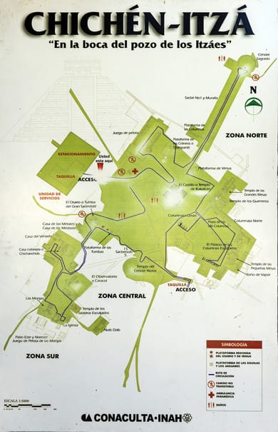
The civic heart of Chichén Itzá is surrounded by a boundary wall and was the ultimate destination of several long, broad stucco-paved roads (plurally known as Sacbeob) leading to surrounding population centers and other areas of importance. This central plaza is essentially an immense platform defined by three great building complexes surrounding it. The buildings along the Great Plaza are seemingly designed in such a manner as to pay homage to Kukulkan, the feathered serpent divinity also associated with a legendary king of the Toltecs who was broadly worshipped in Mexico. Kukulkan was alternatively known as Quetzalcoatl, a manifestation named and revered by the later Aztec empire up through the Spanish conquest.
According to archaeologist Cynthia Kristan-Graham, many structures at the site reflect a concept of city planning known as a ‘Galactic Polity’; at Chichén Itzá, scale replicas of important buildings connect to their larger center by means of a specific Sacbe (ceremonial road). This pattern can be seen at archaeological site of Mayapan as well, which was constructed as a small-scale replica of Chichén Itzá’s monumental core.
To the plaza's west side is the Great Ball Court, the largest in all of Mesoamerica at 154.8 meters in length and bounded by walls reaching over 9 meters in height. The Pyramid of Kukulkan, also known as El Castillo, is located to the south and reaches 30 meters in height with a base extending over 55 meters across. The Temple of the Warriors, located to the east, is a four-platform structure surrounded by 200 round and square columns with bas-relief carvings depicting individual warriors. This temple is very similar in design to the Temple of the Warriors in the Toltec city of Tula, over 1000 kilometers away in the northern Valley of Mexico. The Sacred Cenote is located along a wide stucco-paved Sacbe 300 meters to the north.
Further to the south of Chichén Itzá's Great Plaza are located several smaller building complexes, primarily built in the elaborately-carved Puuc (Yucatec Mayan for Hills) architectural style common in nearby cities, such as Sayil and Uxmal. These building complexes date to the same time period as these cities. While the ceremonial monuments of the Great Plaza are primarily dedicated to the worship of Kukulkan, the constructions to the south are mainly dedicated to the Maya deity Chaak (or Chac), a curl-nosed divinity primarily associated with the bringing of rain; these structures embodied the value of water, as Chichén Itzá was located in a dry tropical forest environment where drought could easily bring widespread famine.
Chichén Itzá contains a relatively wide range of roofing styles, which is unique for a Mayan archaeological site. The site includes rectangular beam-and-mortar structures such as the temple atop El Castillo, wooden or thatch ones such as the roof that probably rested atop El Mercado, and Mexican-styled round structures such as El Caracol. The majority of the structures, however, were built with the traditional Maya corbeled vault, which is a narrow vault made of courses of stone that are projected into an apex, creating a triangular archway. The Nunnery, so-called by the Spanish as they felt it resembled the convents of Spain, features carved stone latticework and Chaak masks decorating the upper facades and corners of the buildings.
Nearby is the fascinating structure known as the Caracol, a stone structure round in plan, that originally generated a cylindrical shape with a domed roof, now partially ruined. Narrow windows cut into the outer walls seem to have been designed in order to observe the irregular movements of Venus, which was considered to be the sun's twin and held great significance for the Maya, particularly in decisions pertaining to war. The staircase at the front of the Caracol faces 27.5 degrees north of west, perfectly in line with the northern positional extreme of Venus and producing alignments at the building's northeast and southeast corners that track both the summer and winter solstices. The Caracol is one of the oldest standing observatories in the Americas, and highlights the great importance that astrological phenomena held for the people of Chichén Itzá.
Source: INAH